Beacon Wood Quarry Excavation, March, 2006
An interim report on archaeological excavations, March 2006
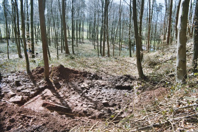
A second phase of research into the archaeological remains preserved within Beacon Wood was undertaken in March 2006 by means of further excavation sampling. The current programme is funded through a grant provided by the Somerset Aggregates Levy Sustainability Fund to the Beacon Hill Society in 2005. Two trenches were opened in the western part of the wood; Trench 2 to examine a proposed alignment of the Fosse Way Roman road and Trench 3 a suspected platform associated with former stone quarrying. The excavations, under the direction of Peter Leach, were carried out with the assistance of volunteers from the Beacon Society, Charterhouse Environs Research Team (CHERT), Bath and Camerton Archaeological Society, Frome Society for local study, and archaeology students from Strode College, Street at the direction of their tutor, Andy Pickering, between 27th March and 1st April 2006. Trench 1 was excavated in October 2005 in the eastern part of the wood to examine another stone quarry site, as the first phase of this research programme.
Trench 2
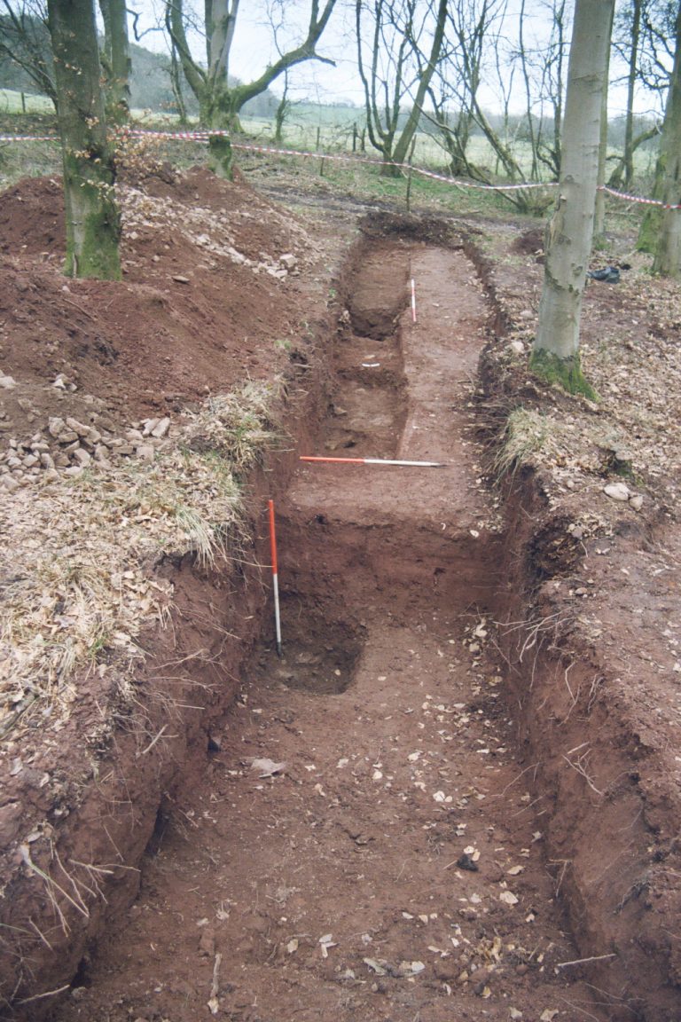
This was cut with the assistance of a mechanical JCB excavator to remove topsoil and overburden, and subsequently to backfill and level the trench site. A trench 16m long and 2m wide was aligned almost east-west across a low, indistinct linear earthwork running alongside and to the west of the modern track identified today as the course of the Fosse Way (Fig. 1). This feature is identified as site no. 1 on the 2002 archaeological survey of the wood (Beacon Hill Wood. An Archaeological Survey 2002-2003, Mark Corney, 2003, for the Woodland Trust). Up to 400mm of surface deposits were removed mechanically to levels where hand excavation could proceed further, except at the western end of the trench where a deeper machined sondage was made to over 1.5m below the surface to obtain a fuller sequence of the natural stratigraphy.
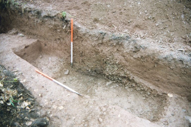
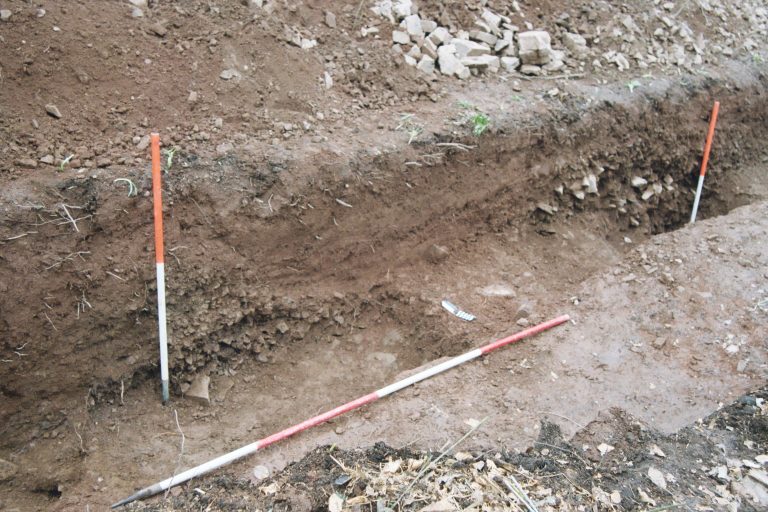
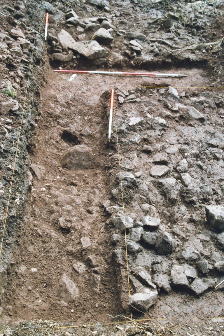
This sondage and hand excavation further east revealed the upper level of a very stony deposit of large tumbled and angular blocks of grey-green andesite rock in a sandy matrix with some voids (layer 2004). This is interpreted as a naturally weathered product of the Silurian volcanic andesite bedrock that underlies this part of Beacon Wood, its formation possibly the result of early post-glacial solifluction processes. In the western part of the trench this level was sealed by over 500mm of much finer pink sand with light scatters of quartz and sandstone pebbles and more numerous small fragments of andesite at its base (layer 2005). At 7m from the west end a steep-sided and flat-bottomed ditch (F202) cut through the sand and into the top of the stony layer 2004. This contained a base deposit of small stone rubble and sand and an upper fill of finer sandy silt (layers 2006 and 2007), both of which had been washed in from the east side. (Fig. 2)
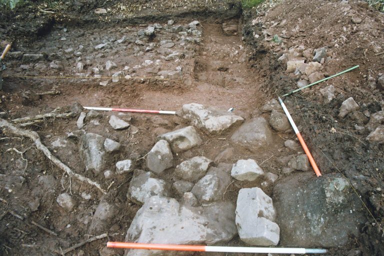
Eastwards, a compact horizontal deposit up to 400mm thick of mixed small stone rubble and sand (layer 2003) above a thin layer of looser, small angular stones (layer 2008) – predominantly andesite – merged into the top of the natural rubble 2004 along the remainder of the trench. Layer 2003 comprised an indistinctly banded mixture of rounded and sub-angular andesite, tuff, some quartz pebbles and sandstone fragments. The surface of this layer was marked by a concentration of worn stone and pebbles, its somewhat uneven surface continuing to the eastern extremity of the trench, where it was more compact and may merge with the western edge of the adjacent modern track (Fig. 3).
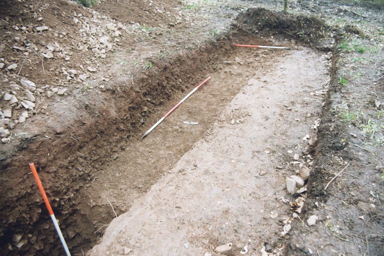
This deposit is interpreted as the remains of the Fosse Way road makeup and a worn surface of latest use (F200). Immediately to the east of and parallel with the side ditch F202 a shallower, concave-profile cut or hollow up to 300mm deep (F201) had removed most of the road material over a 2m width. (Fig. 4) This was filled with finer washed sand (layer 2002), similar in character to the latest deposit, largely removed by machine – a pink-brown silty sand with scattered pebbles and gravel, much penetrated by roots (layer 2001). No more than 200mm of the latter sealed the road but was present to almost 700mm depth further west. It was capped by a thin surface layer of dark humic topsoil, leaf mould, wood and other vegetable matter.
No datable finds were recovered, but the sequence of features and deposits is interpreted provisionally as follows:
- Natural weathering formations and accumulation of material derived from the underlying andesite bedrock – layer 2004; succeeded by finer hillwash sands and silt derived mainly from weathering of the younger Devonian sandstones outcropping on the summit of Beacon Hill to the north – layer 2005.
- A relatively modest ditch cut from the surface of 2005 and aligned broadly north south – F202 , represents the marking out line for and western boundary of a road to the east. No eastern road boundary ditch was found.
- Road foundation material and an uneven, roughly metalled surface at least 9m wide – F200 – is interpreted as the degraded and heavily worn remains of the Fosse Way Roman road.
- The latest phase of road use is marked by a gully – F201 – along its western edge, probably a combination of foot wear and water erosion, and the uneven latest road surface further east. The remains are finally buried by post-Roman hillwash deposits – 2001.
- A new course for the road is established alongside the old to the east, and continuing as the present day track.
Trench 3
Trench 3 was located northwest of Trench 2 and at the base of a steep scarp slope, where the earthwork survey indicated the presence of an artificial platform and a ramp approaching from the southwest (Corney 2003, Survey Map 1, features nos. 2 & 22). See; ‘Beacon Hill Wood. An Archaeological Survey 2002-2003, Mark Corney, 2003’. It was suggested that this might represent a working platform associated with ancient stone quarrying and a trench was laid out across the long axis of the platform (feature 22) and part of the ramp (feature 2). This involved hand clearance without mechanical assistance of an irregular rectangular area 9m long by 4m wide to the north, narrowing to 2m wide southwards towards the ramp (Fig. 1).
Surface vegetation, brushwood, leaf litter and a thin dark humic soil layer were removed, to reveal cleaner surfaces dominated by spreads of large sandstone rubble with pink sands and gravel. Some of these deposits were subsequently examined in more detail by means of a narrower, 1m wide L-shaped trench over the platform 22 (Fig. 2).
During removal of the modern topsoil and vegetation layer (3000) two fragments of post-medieval ceramic tile and a part of a small ball of lead shot were recovered. To the northwest part of an extensive spread of large tumbled sandstone rubble was exposed (layer 3001) – evidently the upper surface of the platform. This was almost exclusively red-brown Devonian sandstone derived from the natural pebble beds and finer sandstone outcrop that caps Beacon Hill, although one or two weathered fragments of carboniferous limestone were also present. There was no suggestion of a laid surface or of worked stones amongst this material.
A portion of this deposit was removed within the L-shaped test trench. To the northwest this revealed a lower horizon of tumbled and angular sandstone blocks mixed with a higher proportion of pink sand and gravel (layer 3004). Up to 500mm of this deposit was removed at the northeast end of the trench against a weathered outcrop of the natural sandstone visible at the surface here (Fig. 3).
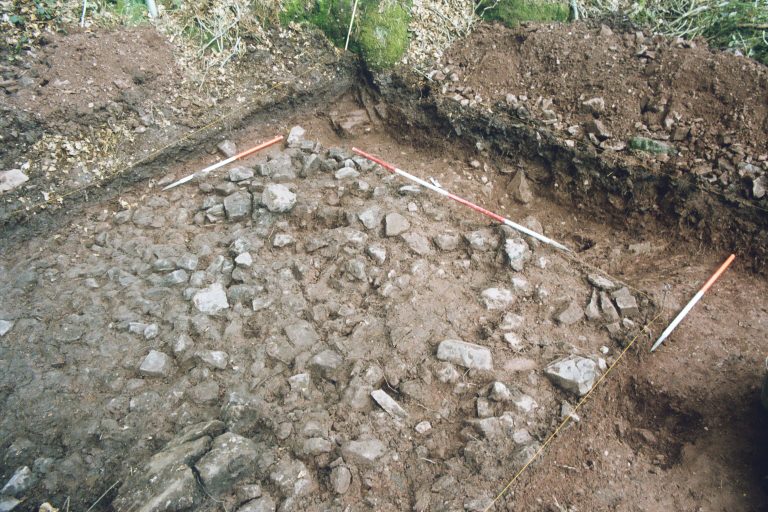
The upper strata, still partially exposed above ground, was a bed of coarse conglomerate, below which the top of a finer bed of sandstone was revealed through excavation. The deposit 3004 was not excavated to its full depth here but a worked flint flake was found within it. Approximately 2.5m to the south removal of 3004 revealed the edge of a cut into a further outcrop of finer natural sand and mudstone rising to within 300mm of the surface. Although not fully excavated within the L- shaped trench the deposit 3004 appears to fill a deeper cut (F300) against a natural rock outcrop sequence of bedded sandstone – probably a narrow quarry excavation into bedrock.
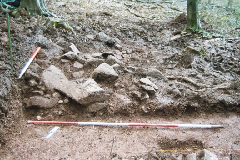
The finer sandstone/mudstone outcrop to the south appears to have been levelled, possibly as a platform for a roughly laid setting of very large sandstone blocks. This comprised part of a rough alignment of stone blocks (Figs. 4 & 5) and some smaller rubble (3002), 1.3m wide and 1.7m long but continuing beyond the trench to the north east. This feature was aligned northeast – south west as a single course of stones marking the edge of the platform to the north, but terminating to the southwest within the trench, possibly destroyed or disturbed by tree planting here. Only a 2m square of the surface of the adjacent ramp was cleared beyond the stone boundary wall to the southeast. This revealed a scatter of large and medium sandstone blocks and rubble in a pink sandy gravel (layer 3003). No further investigation of the ramp or its relationship to the platform was possible, but visual inspection of its surface further downhill indicates a construction incorporating many blocks and fragments of the local sandstone.
The Trench 3 results are interpreted provisionally as follows:
- A narrow quarry (F300) along the base of the Devonian sandstone outcrop (not bottomed) revealed a sequence of coarse conglomerate overlying finer sandstone, above a finer sandstone/mudstone outcrop.
- Upcast from quarrying of the two upper rock formations created the platform (site 22) and subsequently infilled it.
- The lower unquarried mudstone outcrop was levelled as a base for a low revetment wall (3002) along the southeast edge of the quarry site.
- No artefacts or dating material relating to the quarrying were recovered – the prehistoric flint is probably residual, while the lead shot and tile fragments are from the surface.
- Although incompletely excavated, both the geological sequence and the quarry evidence is comparable to that recovered in Trench 1.
During the course of these investigations an opportunity was taken to examine a feature suggested as an artificially created terrace overlooking the holloway complex further north within the wood (site no. 7). A small c 2m square area was cleared of a relatively deep accumulation of leaf litter and organic soil to examine the surface of the terrace. A limited excavation into the tumble of medium and large sandstone blocks with some voids, thus exposed, gave no indication of regular construction or a laid surface. Evidence of extensive quarrying into the steep scarp slope of the hill at this locality probably accounts for this material and the for the terrace feature itself, which appears to have been created as a combination of quarry waste, some natural outcropping of stone and its occasional use as a path.
One further incidental outcome of our operations in the wood was the rediscovery of a missing boundary stone – a rectangular monolith of Doulting limestone lying on its back and buried by leaf litter immediately south of the junction of Holloway 3 with the modern ‘Fosse Way’ track. Inscribed with the letter B and the initials WMFM, this is almost identical to the two surviving boundary stones nearby (sites 28 & 29) erected by William Melliar Foster Melliar, who acquired part of the wood in 1838. The location of this now recumbent stone is very close to its position as depicted on the OS 1:2500 map, 1903 edition, and it may be appropriate to re-erect it at a future date.
These investigations complete the current programme of research into the archaeology of Beacon Wood. Location of remains of the Roman Fosse Way has been a major achievement, although there remains the potential for further exploration of its course elsewhere. A start has been made on a better understanding of ancient quarrying of the sandstone outcrop, as well as of the geology of the hill itself. However, many questions remain, not least a firm identification of the postulated quern and millstone products, more on quarrying techniques, and some firm dating evidence. Another issue concerns the condition and potential of the prehistoric round barrows within the wood. Many of these were damaged when the wood was replanted by the Forestry Commission in the 1950s and it would be of great value to assess this and their present condition with a view to future management, by means of small-scale excavation on or adjacent to some of the non-scheduled sites. It is hoped that these, and possibly other objectives will form the basis for continuing the archaeology programme, which must also include a fuller publication of the results, supported by local voluntary participation and future grants from the Somerset Aggregates Levy Sustainability Fund.
A .pdf version of this figure is available Click here (690kb).
A .pdf version of this figure is available Click here (218kb).
Peter Leach April 2006