In the mid 20th century, Max Unwin, curator of Shepton Mallet Museum was excavating on Beacon Hill. Unfortunately, the excavation notes and models that were kept in the museum are now lost, but we do know that in at least two digs took place, one in January 1949 and one in May 1953.
1949 Excavation
The January 1949 dig gets a brief mention in “The British Caver” volume 25, where the excavation report and survey is described as awaiting publication.
“The Mendip hills consist largely of Old Red Sandstone over-lain by Caboniferous Limestone, but during earth movements when the anticlines and synclines were formed portions of the over-laying strata were worn away, thus exposing the Old Red Sanstone; for example, Beacon Hill (945ft O.D.) near Shepton Mallet.
On this hill by the Beacon (circle of trees) and along the ridge runs the Roman lead road (from Old Sarum to Uphill), which is crossed at this point by the Fosse Way (from Bath to Seaton).
No doubt this “Cross roads” furnished a very commanding position, as from the summit one can gain very expansive views of the surrounding country. Evidence of this commanding position is marked by a small earth works, (1) probably contemporary with the thirteen round Barrows near by. Two years ago I carried out an excavation on the Fosse Way from Shepton Mallet to the Beacon to determine its structure (2).”
The references are listed as:
1) Excavation and Survey report awaiting publication, 1951.
2) “Notes”, Somerset Archaeological Society Proceedings, 1952.
The OSAD (Ordnance Survey Archaeological Division) record card for the area, from 1964 adds the following:
“Excavation in 1949 by Max Unwin of Shepton Mallet Mus. proved road to be 15ft wide and to be directly beneath modern field wall.”
The area of the excavation is shown on the Somerset HER as being between Yellingmill Lane and Bolters Lane.
The Bristol Archaeological Research Group Bulletin for Spring 1968 includes an inventory of Shepton Mallet Musem, amongst the items in the inventory are:
“Shepton Mallet, Bolters Lane (ST 637451), section of Fosse Way model and section drawing, 1949”
1953 Excavation
The most complete record of this excavation comes from a Shepton Mallet Journal article published on Friday 22nd May 1953:
“Burial Mounds of 800BC found
On historic Beacon Hill, Shepton Mallet, site of one of the largest groups of ancient burial mounds in Somerset, six previously unknown bronze [age] burial grounds dating back to 800 B.C., have recently been discovered by Mr Max Unwin, curator of Shepton Mallet Museum. These finds – of foremost importance to archaeologists were discovered within a few hundred yards of the well known ones – four on the east side of the hill, barely a hundred yards apart. Their measurements varied between 35 to 50 feet across, and two or three feet high. Mr Unwin has dug in two or three of the mounds and has discovered human bone fragments and pieces of pottery. Evidence of mound circles on the ground have indicated that cremation of bodies took place before personal belongings and bodily remains were covered with earth and stones.
Deep Ploughed
Commenting on the mounds, Mr. Unwin told our reporter: “It is unfortunate to relate that a few days after I discovered the mounds, Forestry Commission workmen deep-ploughed the hill-top for tree planting on the site, and, unknowingly have almost completely flattened the mounds and scattered the boulder rings.” Owing to the disturbance of the mounds, Mr Unwin expressed the view, that the chances of finding any pottery intact are now very slim, but it is interesting to relate that he has come across pottery shards belonging to the bronze age. Mr. Unwin said that during the course of survey work in 1949 on the hilltop site at Beacon Hill, he came across evidence which suggested that there were two round burial tumuli. When continuing his survey in the same district about three weeks ago he came across soil and topographical evidence that went to show that there were another four burial tumuli – making a total of six mounds which he discovered. Mr. Unwin explained that from barrows which have not been disturbed, an insight can be given into the type of people and culture which moved across the country during those times. That is why, it is so essential that this type of excavating should be undertaken scientifically, to enable an archaeologist to throw light on these ancient remains.
Not Mapped
Regarding the recent ploughing on the identified mounds a Forestry Commission official said “These new barrows were not on the map, and we just had not the faintest idea of their existence. We carefully avoided those that were marked”. Mr. Unwin pointed out that even the smallest piece of pottery found on the surface of such a site can convey a great deal of knowledge to the archaeologist, especially when the find is compared with a distribution map on which all finds are recorded, however insignificant.”
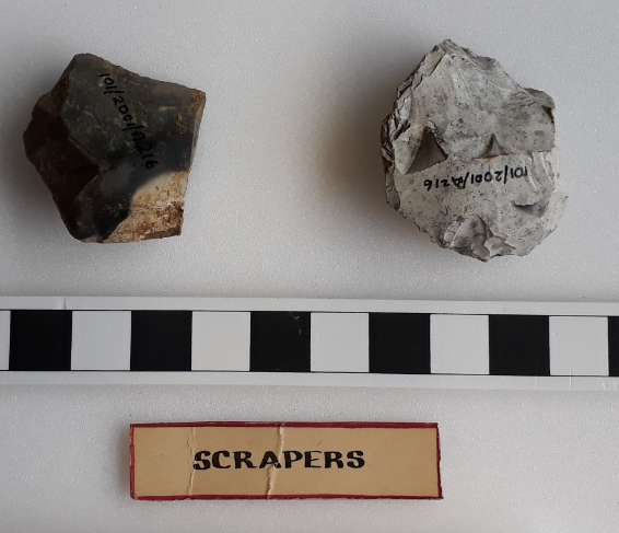
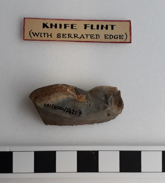
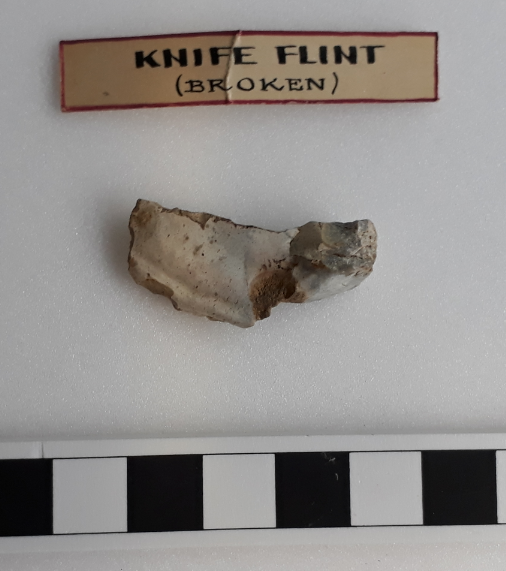
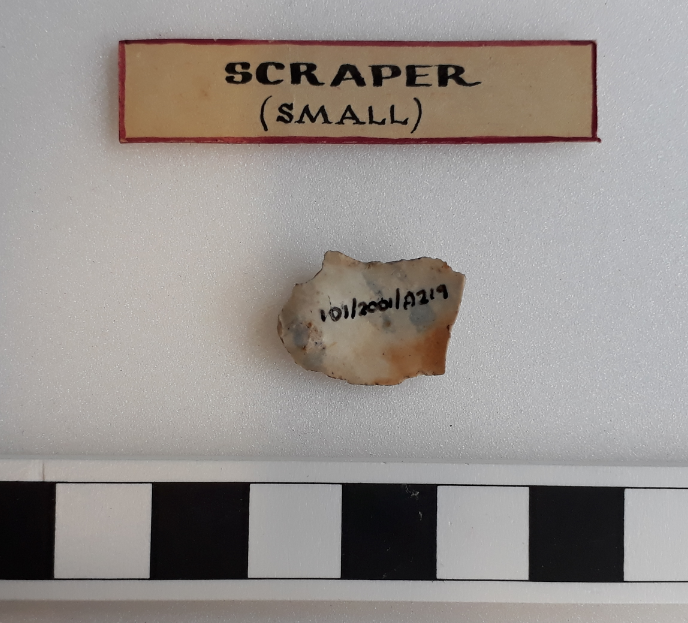
Finds from dig were eventually transferred to Taunton Museum after the closure of Shepton Mallet Museum. They include two flint scrapers (101/2001/A216), a serrated flint knife (101/2001/A217), a broken flint knife (101/2001/A218), a flint scraper (101/2001/A219). It may also include fragments of Iron Age pottery (101/2001/A4), but the Taunton Museum accessions log does not record details for this item.
The dig also gets a mention in the UBSS barrow catalogue (card number T308):
“Disturbed by prairie buster plough. Boundaries difficult to determine. In approx. centre a hollow about 18ins diam and about the same deep noted full of muddy water after heavy rain. Forestry Officer states that a party including school boys did some digging here. ? Was this Unwin and Co. Amount dug insignificant. Has been left unplanted. (Yes, see fraudulent model in S.M. Museum PTO.)
(Overleaf) Some coarse potsherds of the late B.A. style found obviously 2nd burial. Amount dug so small that though plough baulks adjacent to each other and only 2-3ft apart left undisturbed. Total area “dug” about 3×2 ft. Model shows central burnt area with shallow ditch round and 3/4 of barrow dug! = No 12 Shepton Mallet”
Another reference we have is from the Ordnance Survey Archaeological Division (OSAD) record cards (Record ID ST 64 NW 12 (1967)) :
“D – ST 64184583, a bowl barrow partially excavated by Unwin in May 1953 after deep ploughing. Fragments of bones and Bronze Age pottery found. (Shepton Mallet 10)
F – ST 64104582, a bowl barrow 14 paces diam., 2 ft. high (Doulting 7, T 310 a, Shepton Mallet 12)
Excavated by Unwin in May 1953. He discovered a burnt area in the centre, 6 ft. across surrounded by a ditch. The only finds were worked flints including two knives and two scrapers. (3-6)”
The OSAD record card that covers the Fosse Way at Beacon Hill (RR5b) adds:
“Road deviates to the west over Beacon Hill, metalling exposed by deep ploughing c.1953. M.U.”
Finally, the Bristol Archaeological Research Group Bulletin for Spring 1968 includes an inventory of Shepton Mallet Musem, amongst the items in the inventory are:
- “Ashwick, Beacon Hill: sherds of E/MBA urn from barrow mound (Unwin, barrow 12)”
- “Ashwick, Beacon Hill: flints (2 knives? 4 scrapers?) from unspecified round barrow”
- “Ashwick, Beacon Hill: potsherds (surface finds)”